The Site of Murayghat
Murayghat is a site located 3 km south-west of the modern town of Madaba, capital of the Madaba Governerate. Murayghat is located in the limestone hills at the Wadi Murayghat, close to Ma’in and the Wadi Zarqa-Ma’in. The site has multiple components, with archaeological remains stretching over a central knoll and the surrounding hills in the landscape. Towards north and south of the central knoll itself, active limestone quarries were endangering the archaeological remains.
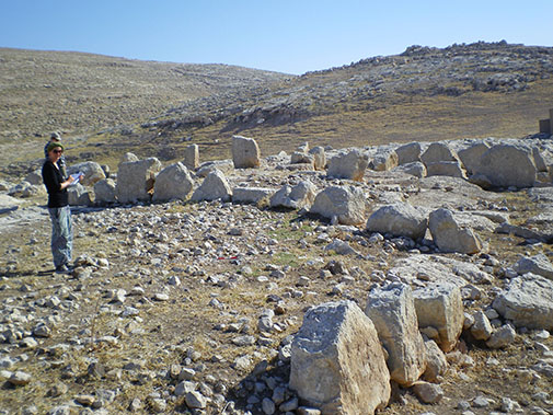
The central knoll has remnants of stone structures consisting of walls, arrangements of orthostats and concentrations of pebble stones surfaces, interpreted as foundation material. Excavations by the staff and field school participants of The Ritual Landscape of Murayghat Project have revealed structures (walls, a platform and a pit) north of the central hill (trench 3-5).On the surrounding hills approximately eighty to a hundred dolmens and a series of caves along with other archaeological remains are scattered in the landscape.

The survey team documents archaeological remains on the centrall hill of Murayghat
Why do we work here?
The Ritual Landscape of Murayghat Project is a survey and excavation project focused on archaeological investigation of the site, but it is also a salvage project. Currently, the landscape around Murayghat is threatened by active limestone quarries and modern developments, resulting not only in the destruction of the main site itself and the dolmens, but also the larger landscape around Murayghat.
The Ritual Landscape of Murayghat Project is focused on documenting the site and the archaeological remains of its hinterland as important, but little known features of Jordanian archaeological heritage. The project emphasizes theoretical approaches such as landscape archaeology and the archaeological study of rituals and the significance of rituals for past societies. The project employs GIS-based documentation to survey, document and study the site.
Based on information from such data as satellite images and maps analysis of view sheds and the like can be generated and used in the interpretation of the site. The aim is to better understand the archaeological periods present at the site and the nature and function of the site in these periods. The survey and excavation at the site and the surrounding hills indicate that there is Late Chalcolithic, Early Bronze Age (EBA), Middle Bronze age (MBA) remains along with lesser evidence from both earlier and later periods.
Read more about the preliminary results of the project in the end of season reports of the previous seasons of the Murayghat project.
What do we find at Murayghat?
The excavations have so far revealed architecture consisting of smaller and larger walls, floors, platforms and storage pits. The finds from the excavation mainly consist of animal bones, ceramics, lithics and ground stone tools. The small finds include metal objects, tesserae and stone objects. The survey of the site and the surrounding hills disclose largely the same types of finds, while identifying and recording the many features present in the landscape, such as dolmens, caves, stone circles and cup marks.
Please see the gallery for photographs of a selection of finds, excavation and survey work.
